Mobile technology has transformed the way we live our lives and has the potential to dramatically assist in demining. However, commercial off-the-shelf (COTS) systems coupled with explosive remnants of war (ERW) related applications leave capability gaps and create potential risks that must be closed. A more tailored and deliberate ecosystem approach when employing mobile technology will yield greater benefits and avoid the problems encountered when Alexa, Cortana, Google Now or Siri do not provide the necessary information. It seems that at the times when you need information the most, the smart personal assistants provided by Google, Apple and Microsoft either provide you with information that isn’t relevant or they don’t provide any information because you do not have a strong enough cell signal to ask them a question.
Since 2010, a diverse team of project managers, software developers, system engineers and testers have supported a U.S. Department of Defense program to determine how best to integrate commercial mobile technology into the military. The challenges and successes of the team resulted in over 3,000 soldiers adopting the capability in support of Operation Enduring Freedom.1 Moreover, the team identified the key attributes necessary to make mobile technology a viable tool for the demining and ERW eradication communities.
Smartphones have made significant impacts in our day-to-day lives. A critical component to the success of this technology is a reliable and robust network that greatly enhances the usability and functionality of these devices while also providing management and security functions from a back-end infrastructure. We frequently see the limitations of standalone devices when we venture into an area with no or degraded service, or place our devices in Airplane mode. Only when we cannot access a map or communicate with others do we fully appreciate the reachback capability as an essential component of mobile technology. These limitations could have catastrophic effects when a device is being used to navigate, maintain situational awareness or develop a common operational picture to support a military operation.
The program identified the need for a full ecosystem approach to mobile technology in order to insure uninterrupted support for our mobile users in Afghanistan. To that end, the ecosystem provides onboard maps (aerial imagery), a customized operating system providing both security and usability enhancements, an integrated framework that allows applications and functions to work seamlessly together and a user-defined, customized suite of applications tailored to the mission, made available through the system’s marketplace. When on a network, functionality such as messaging and viewing the location of other personnel using the devices becomes available. Although the added security measures to protect information exchange within the military may not be needed for demining and ERW activities, a system that is 100 percent reliable and tailored for tactical operations is needed.
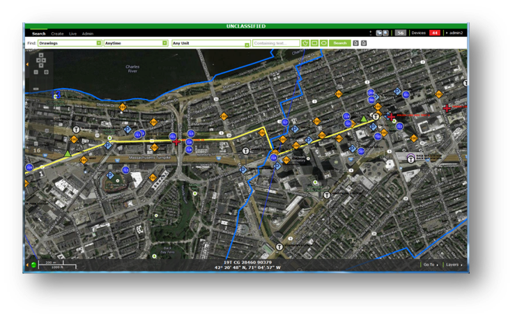
Figure 2. Common operating picture from the 2015 Boston Marathon.
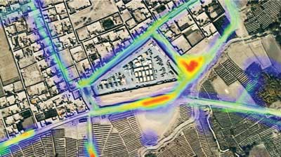
Small commercial drones equipped with cameras capture high-resolution imagery up to 0.3 mm per pixel, convert it into a mobile friendly format using tiling software to create a mosaic dataset from the imagery tiles and have it available for use on a mobile device in less than five hours. This process involves taking a poorly mapped area and transforming it into a highly accurate, near real time visualized operational area. Using planning software, the team transforms this imagery into a clearly marked area with sweep lanes, restricted areas and any other graphical depictions needed to accomplish the mission. Personnel equipped with mobile devices can also add information, such as mine locations and use the camera, video and audio recording functions of the smartphone to further capture critical information. Devices are fully customizable to allow the inclusion of libraries and databases of information (e.g., the Collaborative ORDnance Data Repository) on mines and other ERW to allow for easy identification as well as training and education purposes.
The scalability of the ecosystem enhances its functionality. Something as simple as an ordnance ID guide in the form of an app to assist the local population in identifying potential hazards could be distributed via hardware provided by a relief or humanitarian organization or uploaded to an individual’s personal device. The next level of capability could add a reporting tool for the found ordnance. Using this approach, what would begin as a single capability could grow over time as resources and needs the creation of an entire demining and ERW eradication planning, execution and reporting tool. Regardless of how basic or advanced the tools you employ, the result is the same: a safer environment for the area’s residents. ![]()